Tons of social studies worksheets for teaching students about the fifty states and capitals. Includes maps, games, as well as state & capitals worksheets.
States & Capitals Games
State Capitals Bingo Game Free30 unique bingo cards with the names of state capitals and 50 state calling cards.
States Game: I have... Who has... MemberA set of 34 cards for the states and capitals version of the game, "I have... Who has..."
Board Game: States Trivia MemberPrint this board game with question cards for your students and travel around the USA while answering trivia questions.
Board Game: States & Capitals MemberThis is the same game as the trivia (above), but the questions cards feature only states and capitals questions.
Cootie Catcher: States and Caps MemberMake an origami cootie catcher (also known as a fortune teller) game. Cut, color, fold, and play!
States & Capitals
State Report Project MemberPrintable 5-page state report project packet. There are spaces for listing capital, area, population, climate, etc. Also has spaces to include a picture of state flag and maps.
States and Capitals Quiz MemberAssess student knowledge of the 50 states and capitals. 50 question test includes a mixture of matching, multiple choice, true/false, and other question types.
U.S. Cities & Capitals MemberIn which state would you would find each set of cities? Then, circle the capital city.
States & Capitals #1 - 25 FreeMatch each state with its capital. Part 1 of 2.
States & Capitals #26-50 FreeMatch each state with its capital. Part 2 of 2.
List of States and Capitals MemberA full list of the 50 states and capitals. Makes a great study guide.
State Riddles MemberCan you solve these clever state rhyming riddles?
State Nicknames - Crossword MemberName the Golden State, Empire State, Tar Heel State, and many others.
State Abbreviations #1-25 MemberWrite the abbreviation for each state. Part 1/2.
States & Abbreviations #26-50 MemberWrite the abbreviation for each state. Part 2/2.
U.S.A. Maps
USA Blank Map MemberBlank outline map of the USA without names of states or capitals
USA State Names Map MemberMap of the 50 states with capitals
USA Numbered States Map FreeMap shows numbered states. Students write the state name for each number.
USA Capitals Map MemberMap of the 50 states and capitals
USA Capitals Numbered Map MemberLabel the capital cities indicated by the numbers on the map.
USA Abbreviations Map MemberThis is a map of states with abbreviations shown. Students write the full state name for each abbreviation.
Industry Map of the USA MemberThis map of the USA shows major industries of mining, farming, lumber, oil, and fishing. Use the map to answer the questions.
USA Latitude and Longitude FreeUse this USA map to practice pinpointing latitude and longitude coordinates.
USA Latitude and Longitude 2 MemberAnother map of the continental USA for determining latitude and longitude.
USA Latitude and Longitude 3 (Easiest) MemberAn easier version of the latitude and longitude United States map.
Regions of the USA MemberThis map shows the regional divisions on the United States. Regions include west, midwest, south, midwest, and northeast.
Mystery States
Alabama - Mystery State MemberStudents identify Alabama's map and record factual information.
Alaska - Mystery State MemberStudents try to figure out the state whose shape is shown (Alaska) and then research basic information.
Arizona - Mystery State MemberStudents use a USA map to identify Arizona and record factual information.
Arkansas - Mystery State MemberStudents use a USA map to identify Arkansas and record factual information.
California - Mystery State MemberStudents use a USA map to identify California and record factual information.
Colorado - Mystery State MemberStudents use a USA map to identify Colorado and record factual information.
Connecticut - Mystery State MemberStudents use a USA map to identify Connecticut and record factual information.
Delaware - Mystery State MemberStudents use a USA map to identify Delaware and record factual information.
Florida - Mystery State MemberStudents use a USA map to identify Delaware and record factual information.
Georgia - Mystery State MemberStudents use a USA map to identify Georgia and record factual information.
Hawaii - Mystery State MemberStudents use a USA map to identify Hawaii and record factual information.
Idaho - Mystery State MemberStudents use a USA map to identify Hawaii and record factual information.
Illinois - Mystery State MemberStudents use a USA map to identify Illinois and record factual information.
Indiana - Mystery State MemberStudents use a USA map to identify Indiana and record factual information.
Students use a USA map to identify Iowa and record factual information.
Kansas - Mystery State MemberStudents use a USA map to identify Kansas and record factual information.
Kentucky - Mystery State MemberStudents use a USA map to identify Kentucky and record factual information.
Louisiana - Mystery State MemberStudents use a USA map to identify Louisiana and record factual information.
Maine - Mystery State MemberStudents use a USA map to identify Maine and record factual information.
Maryland - Mystery State MemberStudents use a USA map to identify Maryland and record factual information.
Massachusetts - Mystery State MemberStudents use a USA map to identify Massachusetts and record factual information.
Michigan - Mystery State MemberStudents use a USA map to identify Michigan and record factual information.
Minnesota - Mystery State MemberStudents use a USA map to identify Minnesota and record factual information.
Mississippi - Mystery State MemberStudents use a USA map to identify Mississippi and record factual information.
Missouri - Mystery State MemberStudents use a USA map to identify Missouri and record factual information.
Montana - Mystery State MemberStudents use a USA map to identify Montana and record factual information.
Nebraska - Mystery State MemberStudents use a USA map to identify Montana and record factual information.
Nevada - Mystery State MemberStudents use a USA map to identify Nevada and record factual information.
New Hampshire - Mystery State MemberStudents use a USA map to identify New Hampshire and record factual information.
New Jersey - Mystery State MemberStudents use a USA map to identify New York and record factual information.
New Mexico - Mystery State MemberStudents use a USA map to identify New Mexico and record factual information.
New York - Mystery State MemberStudents use a USA map to identify New York and record factual information.
North Carolina - Mystery State MemberStudents use a USA map to identify North Carolina and record factual information.
North Dakota - Mystery State MemberStudents use a USA map to identify North Dakota and record factual information.
Ohio - Mystery State MemberStudents use a USA map to identify Ohio and record factual information.
Oklahoma - Mystery State MemberStudents use a USA map to identify Oklahoma and record factual information.
Oregon - Mystery State MemberStudents use a USA map to identify Oregon and record factual information.
Pennsylvania - Mystery State MemberStudents use a USA map to identify Pennsylvania and record factual information.
Rhode Island - Mystery State MemberStudents use a USA map to identify Rhode Island and record factual information.
South Carolina - Mystery State MemberStudents use a USA map to identify South Carolina and record factual information.
South Dakota - Mystery State MemberStudents use a USA map to identify South Dakota and record factual information.
Tennessee - Mystery State MemberStudents use a USA map to identify Tennessee and record factual information.
Texas - Mystery State MemberStudents use a USA map to identify Texas and record factual information.
Utah - Mystery State MemberStudents use a USA map to identify Utah and record factual information.
Vermont - Mystery State MemberStudents use a USA map to identify Vermont and record factual information.
Virginia - Mystery State MemberStudents use a USA map to identify Virginia and record factual information.
Washington - Mystery State MemberStudents use a USA map to identify Washington and record factual information.
West Virginia - Mystery State MemberStudents use a USA map to identify West Virginia and record factual information.
Wisconsin - Mystery State MemberStudents use a USA map to identify Wisconsin and record factual information.
Wyoming - Mystery State MemberStudents use a USA map to identify Wyoming and record factual information.
See also:
50 States: Penelope Peabody is LostWhen Penelope Peabody drives across the 50 states, she keeps getting lost. Use the clues to help figure out which state she's in.
Colonial AmericaColonial American maps, worksheets, poems, puzzles, and games.
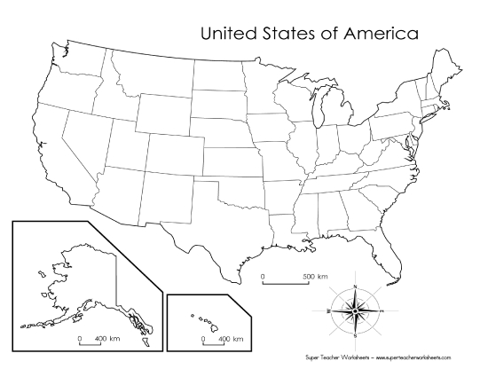
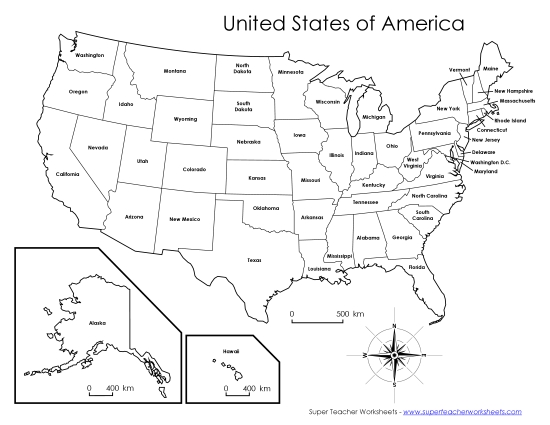
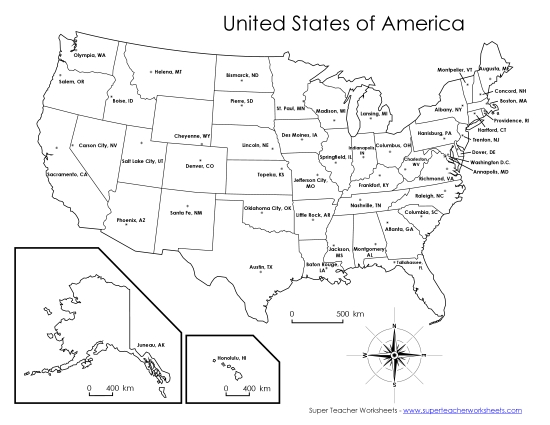
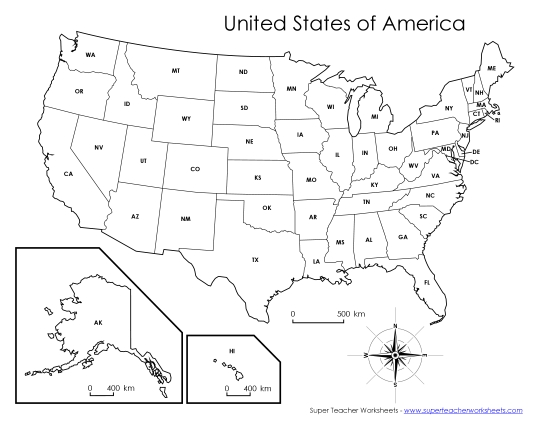
State Maps (Individual States)Super Teacher Worksheets has black-and-white labeled and unlabeled maps for individual states.
Social Studies WorksheetsHere's the complete index of science and social studies worksheets of Super Teacher Worksheets.

